Call: 1-800-832-7191
The Beaufort Scale
October 18, 2021
What is the Beaufort Scale?
The Beaufort scale, officially known as the Beaufort Wind Force Scale, is a descriptive table. That is to say that it depicts the force of wind by a series of numbers from 0 to 12. The scale is named after Sir Francis Beaufort of the British Royal Navy who in 1805 devised a method to describe wind force according to procedures for setting sails on a warship.
By the way, the Beaufort scale goes all the way to 17, but the last five numbers only apply to tropical typhoons. It should go without saying that there is no way possible a human would willingly be out on those waters…we can only HOPE!
Why use it and how can I tell?
So, the Beaufort scale is useful for estimating wind power without wind instruments. As a result of reading the information below you should have a good idea of what to expect from the wind. Likewise, this pertains to all vessel operators including, boaters and paddlers. Always play it safe when it comes to the weather.
The first third of the Scale is not too bad
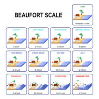
0. Calm and still. Wave Heights 0-0 ft. Calm Sea like a mirror. Smoke rises vertically.
1. Light winds at 1-5 kph (1-3 mph). Wave Heights 0-1 ft. Smoke drift shows wind direction but not by wind vanes. Light air ripples with the appearance of scales form, but without foam crests.
2. Light breeze at 6-11 kph (4-7 mph). Wave Heights 1-2 ft. Light breeze and small wavelets, still short, but more pronounced. Crests have a glassy appearance and do not break. Wind felt on face, leaves rustle, weather vanes moved by wind, and the flag ripples.
3. Gentle breeze at 12-19 kph (8-12 mph). Wave Heights 2-4 ft. Gentle breeze and large wavelets. Crests begin to break. Foam of glassy appearance. Perhaps scattered white horses. Further, leaves and small twigs in constant motion. Moreover, the wind extends light flag.
4. Gentle breeze at 20-28 kph (13-18 mph). Wave Heights 3.5-6 ft. Paper and leaves are scattered. Moderate breeze small waves, becoming larger. Fairly frequent white horses are visible. For example, the wind raises dust and small branches are moved.
The second third of the scale is starting to get scary
5. Fresh breeze at 29-38 kph (19-24 mph). Wave Heights 6-10 ft. Small trees sway, whitecaps form on waves. Fresh breeze Moderate waves, taking a more pronounced long form; many white horses are formed. Small trees in leaf begin to sway; crested wavelets form on inland waters.
6. Strong breeze at 39-49 kph (25-31 mph). Wave Heights 9-13 ft. Umbrellas are hard to use, large branches on trees move. Strong Breeze Large waves begin to form; the white foam crests are more extensive everywhere. Moreover, whistling heard in telegraph wires may be audible.
7. Moderate gale at 50-61 kph (32-38 mph). Wave Heights 13-19 ft. Near Gale Sea heaps up and white foam from breaking waves begins to blow in streaks along the direction of the wind. Whole trees in motion; inconvenience felt when walking against the wind.
8. Fresh gale at 62-74 kph (39-46 mph). Wave Heights 18-35 ft. Gale Moderately high waves of greater length; edges of crests begin to break into spindrift. The foam is blown in well-marked streaks along the direction of the wind. Breaks twigs off trees; generally impedes progress.
The last third of the scale becomes insane!
9. Strong gale at 75-88 kph (47-54 mph). Wave Heights 23-32 ft. Roof tiles blow off buildings. Severe Gale High waves. Dense streaks of foam along the direction of the wind. In addition crests of waves begin to topple, tumble and roll over. Spray may affect visibility.
10. Whole gale at 89-102 kph (55-63 mph). Wave Heights 29-41 ft. Storm Very high waves with long overhanging crests. The resulting foam, in great patches, is blown in dense white streaks along the direction of the wind. On the whole the surface of the sea takes on a white appearance. The tumbling of the sea becomes heavy and shock-like. Visibility affected. Seldom experienced inland; but trees can be uprooted and considerable structural damage occurs.
11. Storm at 103-118 kph (64-73 mph). Wave Heights 37-52 ft. Firstly, this is a violent storm with exceptionally high waves (small and medium-size ships might be for a time lost to view behind the waves). Secondly, the sea is completely covered with long white patches of foam lying along the direction of the wind. Thirdly, everywhere the edges of the wave crests are blown into froth. Visibility affected to nearly none. Very rarely experienced; but can be accompanied by wide-spread damage to vegetation and buildings.
12. Hurricane at 119-220 kph (74-136 mph). Wave Heights 46-56+ ft. The air is fills with foam and spray. Sea completely white with driving spray; visibility very seriously affected. See Saffir-Simpson Hurricane Scale. Hurricane Warnings issued. Hurricane warnings are issued when winds reach 12 on the Beaufort scale. In the same vein, actual hurricane categories are determined by many factors. A 12 on the Beaufort scale is a Category 1 (lowest level) hurricane, but a 13 on the Beaufort scale is not Category 2 it’s actually much, much stronger.
In Conclusion
After reading this you should understand the passion behind the following statement. There are no egos out on the water especially when passengers lives are in your hands. Weather is one of the leading causes of fatalities. Think for a moment about a tragic marine story that doesn’t start with rough weather. Tough to do right. We always preach the mindset of safety first, business second, and fun third.
We here at Connecticut Boating Certificates LLC teach weather tips as a topic in our boat licensing course. Please visit our Public Course Schedule to view our Boat Licensing classes.
Here are a couple of great links from National Geographic and Weather.gov: Beaufort scale | National Geographic Society Beaufort Wind Scale at Weather.gov