Call: 1-800-832-7191
Nautical Charts and Boating
July 5, 2021
WHY USE A NAUTICAL CHART
Nautical Charts and Boating go way back. They say that many boaters are judged by their ability to navigate. Not sure who “they” are but I guess its true. Nautical Charts help us navigate in real time. Consequently charts help us plan our trip in the first place. In short, charts give us a sense of security on the water. It allows an operator to navigate through unknown waters. Did you know that paper charts are used just as much now as electronics. Incidentally, professional nautical charts are FREE. Indeed, one of the most loved words in our language! So we have added a link at the bottom of this blog for you to partake.
One of the biggest fears for boaters is what lies beneath the waterline. Do you think this is a new concern? Of course its not. This is why nautical charting goes back hundreds of years. Take a few minutes to read on and have a basic understanding of a Nautical Chart.
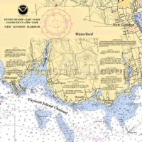
WHAT ELEMENTS APPEAR ON A NAUTICAL CHART
What can we find on a chart? Firstly, water depths or soundings, and clearances. In fact, water depths show at low tide. Bridge clearances show at high tide. Nice to know. Secondly, rocks, reefs, lighthouses, and buoys to name a few. Before electronics were even a thought on a vessel operators wanted to know about obstructions. This is why charts are very thorough. They have been worked on for many moons my friends. Thirdly, charts give us the bottom type. Pretty helpful information when boaters want to anchor. It’s why we say Nautical Charts and boating go hand and hand.
To clarify, one can look at a chart and get what’s going on. That being said, the coloring on a chart is important. The colors are pretty universal with both paper and electronic charts. The white indicates the deeper waters. The blue indicates the shallow waters. Lastly the Tan, Olive, Dark Tan colors indicate land.
To limit this blog we’ll point out just a few more. A compass rose will appear on all paper charts. It is important to understand that a compass rose has two circles. The outer circle is True North hence the zero points to the North Pole. On the other hand the inner circle is Magnetic North hence the zero points to Magnetic North. The difference between the two is called Variance. This may equate to setting on your Boat’s GPS. The last thing we’ll mention here, and there is so much more, is Land Indicators. Land indicators are important because boaters can see them from the water. A boater can triangulate their position very quickly using a land indicator. An example of a land indicator may be a tower, smoke stack, or a water tank.
SHOULDN’T I JUST USE MY ELECTRONICS
This is a very popular question. GPS equipment has been a blessing and you should absolutely use it. In fact not many boaters travel with paper charts anymore. You should use paper charts primarily in the planning phases nowadays. It’s easy to download and print a chart and then write all over it. It’s also kind of fun! Use paper when you are talking about your trip at the kitchen table. If you are planning to visit a new marina, check out the paper. You also find buoys and traffic funnels on a chart. You can plan your approach that way. Bring your paper chart with you on your journey.
Again, all this being said, do not throw your GPS out! It is an awesome tool. Rather use paper to accentuate your experience. Find the chart for your area and challenge yourself. Find something you didn’t know about. You’ll have fun doing it as well. You’ll understand why nautical charts and boating have been around for so long.
IN CONCLUSION
Do not travel into unknown waters with out knowing the Nautical Chart of that area. That is simply foolish and dangerous. Do not travel into unknow waters with only the knowledge of this article. There are classes available and plenty of information as well. Most of this information is free. However, always remember, there are no egos when passengers’ lives are in your hands. As always, be smart and safe out on the water.
Please visit our Public Course Schedule to view all of the classes we have available for you. Zoom Classes are available now. There has never been an easier way to get your Boating Certificate. We also offer Navigation Classes and Seminars.
Here is a great link to NOAA’s digital catalog of downloadable Nautical Charts (PDF format). Chart Locator (noaa.gov)